Iceland
2 –Identifying Landmarks
Iceland is the result of 64 million years of continual
transformation and rebirth. It has been shaped by the unpredictable antics of
volcanoes, glaciers and earthquakes.
Iceland precariously sits astride two opposing
tectonic plates. The island expands at a similar rate as its coastline erosion.
I gleaned these facts, and others, from Perlan Wonders
of Iceland exhibition setup in an extensive complex overlooking the capital,
Reykjavik. Amongst the extensive exhibitions over four levels is an ice cave
made from glacier ice.

The top floor is appropriately a revolving
café/restaurant. Glancing through the facts of Iceland I could not help
thinking they could have been referring to New Zealand.
Wonders of Iceland was a great experience but did not
quite match the excitement of venturing to the real thing. Our experience
included joining two guided day tours; one with Gray Line and the other with
Reykjavik Excursions. Both were excellent. Guides were informative.
Gray Line treated us to the Golden Circle highlights
to the east of the capital. A history lesson was at Bingvellir where we could
walk through a cleft formed by an active fault line. It is claimed this wild
site was where the Icelandic State was born during Viking times. Curiously,
that inaugural so-called `first parliament’ agreed to introduce Christianity to
Iceland. During the proceedings the ground violently shook with an earthquake.
Participants questioned whether the idea of Christianity had upset their
traditional Norse gods? Those present stuck with the Christianity decision.
These days Icelanders are typically staunch Lutherans.
The first scenic blockbuster was Gullfoss Gorge where
we were let loose to explore the furious waterfalls. In appearance Gullfoss was
a threatening dramatic environment.
Gullfoss Gorge has been a Nature Reserve since 1979. It
was formed when a flash flood in the Hvita River forced its torrent through
cracks in basalt lava layers. The usual flow is 109 cu metres/second. It has
reached 2000 cu metres /sec.
Paths and
protective fencing allow for close viewing. The challenge was to keep my camera lens dry
from continuous fine spray.

I was amused to discover a love story associated
with Gullfoss:
``No-one can cross the Hvita River upstream from the
waterfall, even on horseback. A
seventeen century story relates to the son of a Brattholt farmer who looked
after sheep in pastures upstream. Across the gorge a saucy girl from Hamursholt
also looked after sheep. They noticed each other, and kept an eye on each other
–the swift Hvita between them. A fondness blossomed. Eventually, the girl
pleaded with him to come across. He
found the shallowest place, and set out to wade the torrent. It must have been
a harrowing experience for the girl to watch but he made it to her. How he was
greeted is, sadly, not recorded. We are told they married and had many well-respected
descendants.’’
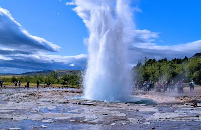
Next stop was at Geysir (Icelandic spelling for
geyser) to experience the thermal reserve and the active geyser, Strokkur. It curiously formed a large
dome on the holding lake through which, moments later, the geyser blasted. Iceland
is one of five countries with active geysers. New Zealand is among the others.
Reykjavik
Excursions took us to the south coast. We paused to see the Eyjafjallajokull
ice cap volcano. It infamously awakened from dormancy on April 14, 2010. The eruption was relatively small as far as
volcanic events go. Nevertheless a plume of ash 250 cubic metres across rose to
nine km. The ash cloud drifted south-wards across Europe disrupting air
traffic. 10 million travellers were compromised.
Reporters around the world struggling with pronouncing the name Eyjafjallajokull caused a perverse sense
of pride amongst Icelanders.

Nearby we walked to the Myrdalsjokull Glacier which
sits on the larger volcano, Katla. Katla has erupted about 20 times since Iceland
was settled. The last occasion was in 1918. Volcanoes erupting beneath glaciers
cause tremendous ice melting. Flash floods rising within a few hours can be 100,
000 to 3000,000 Cu metres/sec. Myrdalsjokull is Iceland’s fourth largest
glacier and the most southern. Icebergs in the glacier’s terminal melt lake are
tarnished with black ash. The same volcanic ash formed black sands along the
nearby coastline.

Our day included several waterfall experiences, one (Seljalandsfoss)
we could precariously walk behind. I made the dripping experience with some
difficulty. On a final steep pinch a welcome strong hand gave a reassuring shove
from behind.
We have stunning waterfalls in New Zealand but those
in Iceland are enhanced by incredible volumes of water. Skogafoss, one of
Iceland’s largest, tumbles 62 metres from a plateau. It is 25 metres wide. One
looking for a thrilling, albeit wetting, experience can walk a short distance
up the Skoga River to the base of the falls.
The mist spray ensures a rainbow when the sun shines. We enjoyed a close
encounter with Skogafoss. The miracle is we were not all drowned. Legend has it that behind the waterfall
one can find treasure. A chest filled with gold and other treasures was hidden
there by Þrasi Þórólfsson, a Viking Settler at
Skógar (Eystriskógar) around 900. It is yet to be found.

No comments:
Post a Comment